Toggle navigation
Survey Documents
Advanced Search
Supporting Data
Companies
Surveyors
Communities
Original Townships
APIs
Survey Documents API
Tutorial
About
Contact
Search
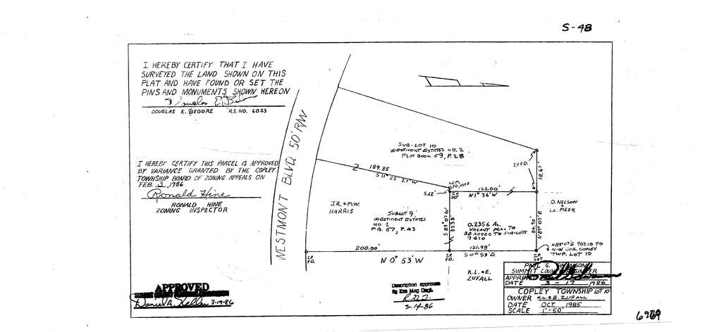
6969
Download lotsplits6969.tif
GIS Data
Latitude:
41.1284291999999
Longitude:
-81.6712842
Identification
Survey identifier:
6969
Context
Original township:
Copley
Community list:
Copley
Surveyed on:
10/01/1985
Description
Owner:
Zufall
Description:
Sub Lot 9 Westmont Estates #1 P.B. 67 Pg,43. Lot 10 Westmont Estates Pb. 69 Pg 28
Primary road:
Westmont Blvd
Secondary road:
Near intersection:
Silver Ridge Dr
Acreage:
0.2356
Survey Locators
Tract list:
Lot list:
10
Section list:
Quarter:
Surveyor
Surveyor number:
6023
Surveyor name:
Bedore, Douglas E.
Company:
Bedore Surveying
Document Data
Scan File Name:
lotsplits6969.tif
Scan Pages:
1
Drawer location: